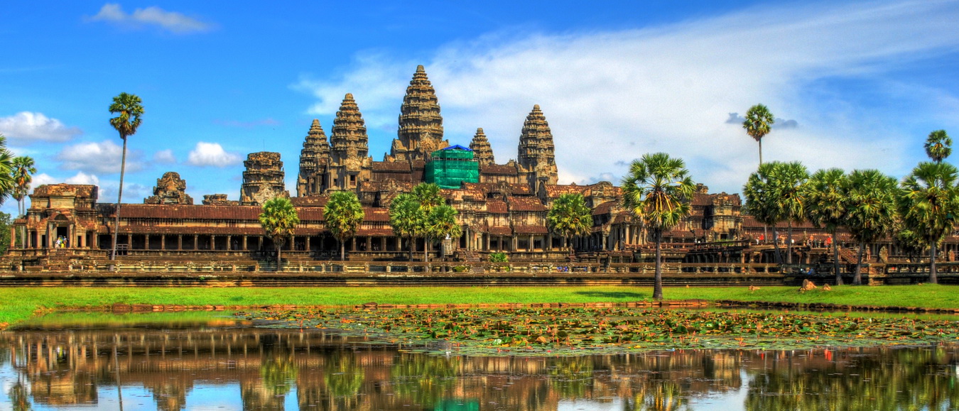
Cambodia has a land area of 181,035 square kilometers in the southwestern part of the Indochina peninsula, about 20% of which is used for agriculture. It lies completely within the tropics with its southernmost points slightly more than 10º above the Equator.
The country’s capital city is Phnom Penh. International borders are
shared with Thailand and the Lao People’s Democratic Republic on the
west and on the north, and the Socialist Republic of Vietnam on the
east and the southeast. The country is bounded on the southwest by the
Gulf of Thailand. In comparison with its neighbors, Cambodia is a
geographically compact country administratively composed of 20
provinces, three of which have relatively short maritime boundaries, 3
municipalities, 172 districts, and 1,547 communes. The country has a
coastline of 435 km and extensive mangrove stands, some of which are
relatively undisturbed. The dominant features of the Cambodia landscape
are the large, almost centrally located, Tonle Sap (Great Lake) and the
Bassac River systems and the Mekong River, which crosses the country
from north to south.
Surrounding the Central Plains which covered three quarters of the country’s area are the more densely forested and sparsely populated highlands, comprising: the Elephant Mountains and Cardamom Mountains of the southwest and western regions; the Dangrek Mountains of the north adjoining the Korat Planteau of Thailand; and the Ratanakiri Plateau and Chhlong highlands on the east merging with the Central Highlands of Vietnam.
The Tonle Sap Basin-Mekong Lowlands region consists mainly of plains with elevations generally of less than 100 meters. As the elevation increases, the terrain becomes more rolling and dissected. The Cardamom Mountains in the southwest rise to more than 1,500 meters and is oriented generally in a northwest-southeast direction. The highest mountain in Cambodia – Phnom Aural, at 1,771 meters – is in the eastern part of this range.
The Elephant Range, an extension of the Cardamom Mountains, runs toward the south and the southeast and rises to elevations of between 500 and 1,000 meters. These two ranges are bordered on the west by a narrow coastal plain facing the Gulf of Thailand that contains Kampong Som Bay. The Dangrek Mountains at the northern rim of the Tonle Sap Basin, consisting of a steep escarpment on the southern edge of the Korat Plateau in Thailand, marks the boundary between Thailand and Cambodia. The average elevation of about 500 meters with the highest points reaches more than 700 meters. Between the northern part of the Cardamom ranges and the western part of the Dangrek, lies an extension of the Tonle Sap Basin that merges into the plains in Thailand, allowing easy access from the border to Bangkok.
The Mekong River, Cambodia’s largest river, dominates the hydrology of the country. The river originates in mainland China, flows through Myanmar, Laos, Thailand before entering Cambodia. At Phnom Penh, with its alternative arms, the Bassak River form the south, and the Tonle Sap River linking with the “Great Lake†itself – Tonle Sap – from the northwest, it continues further southeastward to its lower delta in Vietnam and to the South China Sea.
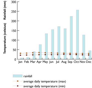
The section of Mekong River passing through Cambodia lies within the tropical wet and dry zone. It has a pronounced dry season during the northern hemisphere winter, with about 80% of the annual rainfall occurring during the southwest monsoon in May-October. The Mekong River’s average annual flow at Kratie of 44km3 is estimated as 93% of the total Mekong run-off discharge into the sea. The discharge at Kratie ranges from a minimum of 1,250m3/s to a maximum 66,700m3/s.
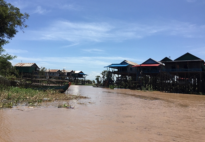
The role of the Tonle Sap as a buffer of the Mekong River system floods and the source of beneficial dry season flows warrants explanation. The Mekong River swells with waters during the monsoon season reaching a flood discharge of 40,000 m3/s at Phnom Penh. By about mid June, the g flow of the Mekong and the Bassac Rivers fed by monsoon rains, increases to a point where its outlets through the delta cannot handle the enormous volume of water, flooding extensive adjacent floodplains for 4-7 months. At this point, instead of overflowing its banks, its floodwaters reverse the flow of the Tonle Sap River (about 120 km in length), which then has a maximum inflow rate of 1.8 m/s and enters the Great Lake, the largest natural lake in Southeast Asia, increasing the size of the lake from about 2,600 km2 to 10,000 km2, at times exceptionally to 13,000 km2, and raising the water level by an average 7m at the height of the flooding. This specifity of the Tonle Sap River makes it the only \\\"river with return\\\" in the world.
After the Mekong\\\'s waters crest, the flow reverses and water flows out of the engorged lake. The Great Lake then acts as a natural flood retention basin. When the floods subside, water starts flowing out of the Great Lake, reaching a maximum outflow rate of 2.0 m/s and, over the dry season, increase mainstream flows by about 16%, thus helping to reduce salinity intrusion in the lower Mekong Delta in Viet Nam. By the time the lake water level drops to its minimum surface size, a band 20-30km wide of inundated forest is left dry with deposits of a new layer of sediment. This forest, which is of great significance for fish, is now greatly reduced in size through deforestation. The area flooded around Phnom Penh and down to the Vietnamese border is border is about 7,000km2.